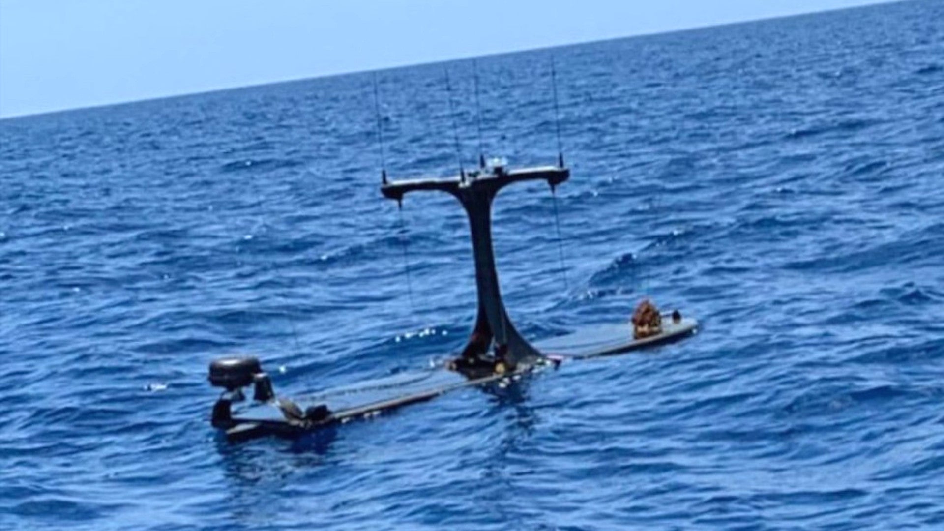
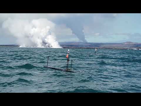
Last week, boaters sailing off the Florida Keys caught sight of an unusual small unmanned surface vessel festooned with antennas. By every indication, the craft appears to be Wave Glider from Liquid Robotics, which is now a division of Boeing. Its configuration, including a prominent antenna array associated with electronic intelligence-gathering systems, points to its involvement in one of a number of persistent maritime surveillance projects, which have been a growing area of interest for the U.S. military, and for the U.S. Navy in particular, in recent years.
FishMonster Magazine, which is “all about the fishing, diving and boating lifestyle in the Florida Keys, Cuba and the Bahamas,” posted the video on its Facebook page on June 24, 2020. Captain Marlin Scott narrates the video from his boat, the Premium Time, which operates as part of FishMonster Charters.
“I have no idea what it is,” Scott says in the video. “Its got transponders on it. It looks like its got antennas.”
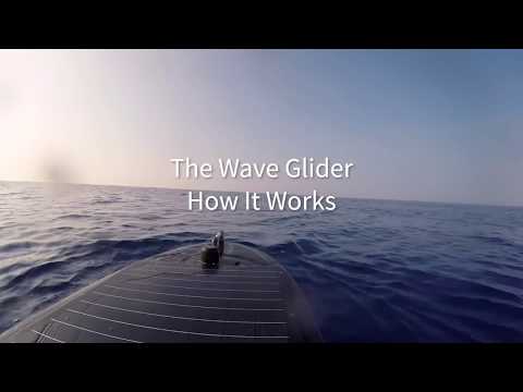
Our friend H.I. Sutton, an expert on all things that sail under the waves, was first to identify the underlying craft as most likely a Liquid Robotics Wave Glider. The “float” seen bobbing the surface is just one part of the complete system and is linked via a 26-foot-long cable to another one underwater.
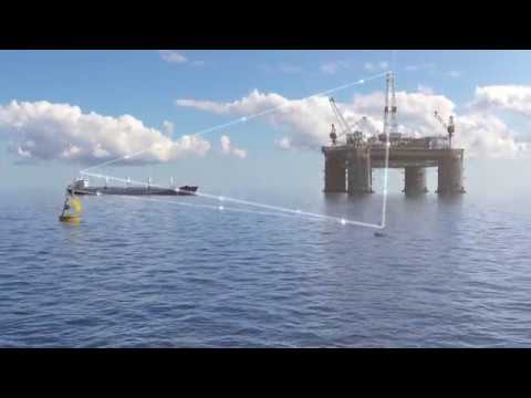
The momentum of the currents propels the underwater float, pulling the entire system along. In the case of Liquid Robotics’ design, the float on the surface also has solar panels that can provide power to a small motor to provide auxiliary propulsion, if necessary. The video below shows how the basic design works.
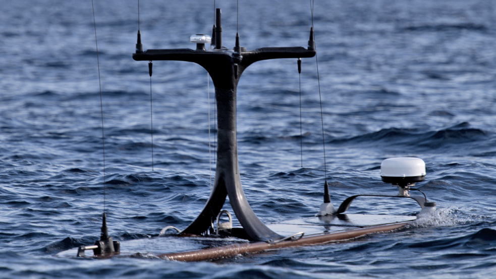
The example that Captain Scott and his passengers spotted off the Keys has a number of features that do not appear on any of the Wave Gliders in any of Liquid Robotics promotional materials. Most notably, it has an antenna array mounted on an x-shaped frame fitted to the top of the float on the surface.

This type of antenna is most commonly associated with relatively compact electronic support measures and signals intelligence systems with direction-finding capabilities. The U.S. military employs a number of systems that use these types of antennas, including the U.S. Army’s man-portable Wolfhound signals intelligence system.

There is also a circular, dome-shaped antenna toward the rear of the float, which could house a satellite communications system or some form of tracking transponder. A satellite communication system would allow the craft to transmit whatever data it is collecting to other locations for additional processing and to simply allow for remote monitoring. A transponder would also allow personnel elsewhere to keep tabs on the status of the Wave Glider.
Other thin whip antennas and protrusions, which might also hold antennas, are visible, as is what appears to be the float’s solar panel.
There are no features that clearly identify the craft’s owner, its specific purpose, or whether or not this is part of a test or experiment. However, the configuration very likely point’s a military operator and mission.
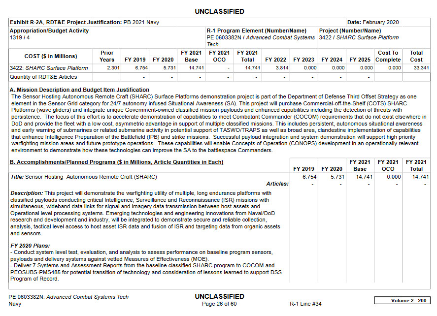
Forbes noted that at least as early as 2011, the U.S. Navy had announced plans to use Liquid Robotics’ Wave Glider as part of its Sensor Hosting Autonomous Research Craft (SHARC) program together with a Towed Integrated “L” (TAIL) acoustic sensor array. The manufacturer has also highlighted how the unmanned craft can carry and deploy small towed sonar arrays, as well.
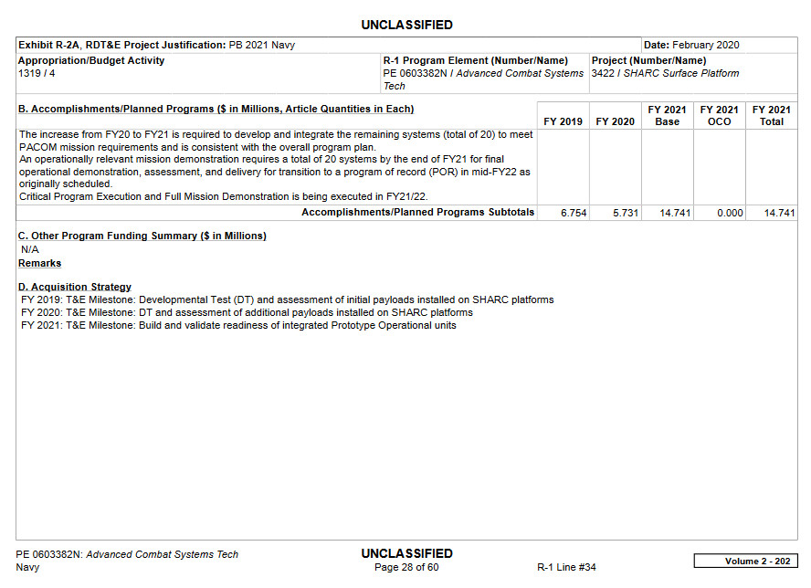
The goal of the SHARC effort is to “provide the fleet with a low cost, asymmetric advantage in support of multiple classified missions,” according to the Navy’s most recent budget request for the 2021 Fiscal Year, the relevant portions of which are seen below. “This includes persistent, autonomous situational awareness and early warning of submarines or related submarine activity in potential support of TASWO/TRAPS as well as broad area, clandestine implementation of capabilities that enhance Intelligence Preparation of the Battlefield (IPB) and strike missions.”
“TASWO/TRAPS” is “Theater Anti-Submarine Warfare Operations/Transformational Reliable Acoustic Path System. TRAPS is a network of fixed passive sonar nodes that lie on the seabed, which you can read about in more detail in this past War Zone piece. The Navy also uses underwater gliders to support the TRAPS network, as well as perform other missions, such as oceanographic surveys. China notably briefly seized one of those undersea drones, which it might have believed was conducting intelligence-gathering or surveillance operations, in the South China Sea in 2016.
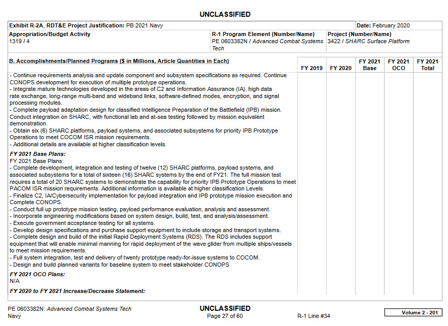
“Obtain six (6) SHARC platforms, payload systems, and associated subsystems for priority IPB Prototype,” is one of the SHARC program goals for the current 2020 Fiscal Year, according to those same budget documents. “Complete payload adaptation design for classified Intelligence Preparation of the Battlefield (IPB) mission” and “Conduct integration on SHARC, with functional lab and at-sea testing followed by mission equivalent demonstration.” are also listed on the agenda for this fiscal cycle.
Intelligence preparation of the battlefield typically involves collecting various types of information about the disposition and capabilities of expected enemy forces in the area of interest. This would include using electronic support measures and signals intelligence systems to spot, classify, and geolocate hostile emitters to help build an “electronic order of battle” of hostile units.
It’s also worth noting that Liquid Robotics proposed using its Wave Gliders configured with various sensors and communications systems to support the Defense Advanced Research Projects Agency’s (DARPA) Ocean of Things program. DARPA first unveiled this project in 2017.
“DARPA’s Oceans of Things program seeks to enable persistent maritime situational awareness over large ocean areas by deploying thousands of small, low-cost floats that form a distributed sensor network,” according to the official project page. “Each smart float contains a suite of commercially available sensors to collect environmental data – such as sea surface temperature, sea state, and location – as well as activity data about commercial vessels, aircraft, and even maritime mammals moving through the area. The floats transmit data periodically via satellite to a cloud network for storage and real-time analysis.”
Liquid Robotics has dubbed its particular concept for providing this persistent surveillance and situational awareness capability as The Digital Ocean. However, the Wave Gliders it depicts as supporting this effort in concept art and videos, or the ones that it has actually tested in environmental surveillance roles, are not configured in the same way as the one seen off the Florida Keys.
Whatever the exact intended use of this particular Wave Glider is and what project it is a part of, the value of using networked groups of craft like this as low-cost distributed sensor and communications relay nodes is clear. One of the greatest challenges facing the U.S. military today is how to realistically maintain even basic situational awareness of what is going on above and below the waves across broad swathes of ocean, especially in the Pacific region, as well as in congested and complex littoral areas.
SHARC and the Ocean of Things are just some of the projects aimed at finding solutions to these and adjacent problems. Other known programs in the works along similar lines include rapidly-deployable, but powerful containerized sonar arrays – a test of which led Croatian fisherman to recover another mysterious maritime object earlier this year that turned out to be Navy property – and a tangential DARPA effort to explore using changes in the behavior of fish and other marine life to identify the presence of enemy submarines.
The Navy is also testing its Sea Hunter unmanned surface vessel a larger persistent maritime surveillance platform with a particular focus on anti-submarine warfare. Sea Hunter started as a DARPA project known as the Anti-Submarine Warfare (ASW) Continuous Trail Unmanned Vessel, or ACTUV. Sea Hunter is also slated to take on additional roles in the future and the Navy is trying to expand its unmanned surface and underwater fleets and have them take on more and more missions, in general.

A large number of Wave Gliders equipped with even basic sonar and acoustic sensors and operating autonomously could provide an additional useful layer of information and spot underwater objects of interest for further investigation by more capable anti-submarine platforms. They have the benefit of being virtually silent and otherwise small and hard to detect themselves.
With other sensors, such as electronic support measures and signals intelligence suites, they could gather additional information about surface vessels, aircraft, or even targets along the shoreline. Wave Gliders with multiple systems or groups of them in different configurations could be deployed as multi-purpose networked maritime surveillance arrays providing a breadth of useful information for military and civilian purposes.
Even just a number of wave gliders spread out over a large area and equipped with a similar ESM suite could not only detect and track relevant radio frequency emissions, but by fusing their data together at a central remote hub that may be located thousands of miles away, they could geolocate those emissions with great accuracy. You can imagine how useful this could be for monitoring air and surface radio communications and RF sensor traffic over a huge swathe of ocean. It represents a remarkably cheap and persistent alternative to other platforms that wouldn’t benefit from the distributed nature of these wave gliders.
Liquid Robotics says the craft can operate for up to 12 months at a time with little to no maintenance. Lost Wave Gliders could be replaced relatively quickly and cheaply. This would also mean they could be easy to deploy into choke points or other areas of interest on short notice, as necessary. This will be important for operating in increasingly contested areas, such as the South China Sea.
The reality is that if they were networked together, even in a rudimentary fashion, others could adapt to best optimize their position if one is lost. In essence, the same tenets of aerial unmanned swarm warfare cross over to the unmanned surface vehicle space.
We are in the process of reaching out to Liquid Robotics and the Navy to hopefully get more information about this particular Wave Glider and its purpose and capabilities. We will be sure to follow up if we learn anything new about this craft, could have exciting future implications for persistent surveillance of the world’s waterways.
UPDATE:
Thanks to @Johann_U96 we have absolute confirmation that this wave glider does indeed carry an electronic intelligence package that is pretty much exactly as we postulated above. It is built by ThayerMahan, a Grotton, Connecticut-based defense contractor. It is called SeaWatch and is described by the company as such:
The SeaWatch system consists of an autonomous electronic surveillance package mounted on an autonomous surface vessel. Its purpose is to provide a long dwell maritime capability to detect electronic emissions related to illicit maritime activity.
SeaWatch detects emissions that are either too weak to be picked up by more distant means, and also assists in localizing emissions by providing additional bearings from a different aspect relative to the emittor.Utilizing off-the-shelf equipment, internal development, and strategic partnerships, ThayerMahan has developed a system to continuously monitor the seas for RF activity. The ultra-endurance unmanned surface vehicle that hosts the payload, allows for self-sustained mission times of 90 days or greater. This monitoring, combined with the DF software, allows for an effective means to track down and intercept targets of interest.
A user-friendly interface allows for the active tracking of multiple RF bands at once and access to recorded transmissions all on the same screen. Activity of interest is recorded and stored for further analysis, even with no active user monitoring the interface. SeaWatch communicates via BGAN Satellite Internet coverage, so detection and interdiction is possible anywhere on the water.
SeaWatch has demonstrated the ability to exfiltrate sensor data directly to a client facility or to ThayerMahan’s Ops Center in Groton, CT. This proprietary system/capability uses an autonomous Radio Frequency (RF) interceptor and accompanying Direction Finding (DF) software.
SeaWatch’s long-endurance, low-observable, unmanned surface vehicle, with its integrated electromagnetic signals (ES) sensing system, recently completed a successful 84-day on-station mission for a US Government client.
UPDATE:
In a recent notice to mariners, the Coast Guard specifically mentions ThayerMahan’s wave glider operations. The info gives us new details about how many are in operations and who they belong to—four off Florida, right where our wave glider in question was found and one off the east coast. We also know that they have a sense and avoid capability for ships with AIS:
FLORIDA – STRAITS OF FLORIDA – MARATHON TO DRY TORTUGAS: SURFACE WAVE GLIDER DEMONSTRATION
ThayerMahan, Inc. will be demonstrating up to four autonomous, unmanned maritime vehicles (Wave Glider-WG) in the Straits of Florida between Marathon and Dry Tortugas. The demonstration will commence on or about 08 June, 2020 and is expected to terminate on or about 31 July,2020. 24/7 operations consist of system evaluation and scientific ocean data collection. The Wave Glider carries no fuel, lubricants or hydrocarbons. It is wave powered and remotely attended from the ThayerMahan Operations Center, moving at speeds of about 1kt, and is designed to automatically give way if encountered by a vessel transmitting AIS. It is approximately 6.5’ x 2’ (surfboard size), copper in color, with a contact plaque and mast extending 3’ above the water surface. Mariners are requested to transit the area with caution. For more details contact the ThayerMahan Operations center at 860-969-3171.
…
ATLANTIC OCEAN – EAST COAST – OFFSHORE: SURFACE WAVE GLIDER DATA COLLECTION
ThayerMahan, Inc. will be transecting one autonomous, unmanned maritime vehicle (Wave Glider-WG) from approximately 100NM east of PortCanaveral, FL to about 100NM east of Cape May, NJ. The transit will commence on or about May 27, 2020 and is expected to terminate on or about August 27, 2020. Operations will run 24/7 and consist of scientific ocean data collection. The Wave Glider carries no fuel, lubricants or hydrocarbons. It is wave powered and remotely attended from the ThayerMahan Operations Center, moving at speeds of about 1kt, and is designed to automatically give way if encountered by a vessel transmitting AIS. It is approximately 6.5’ x 2’ (surfboard size), copper in color, with a contact plaque and mast extending 3’ above the water surface. Mariners are advised to requested to transit the area with caution and to remain a safe distance from the wave glider. Further information contact the ThayerMahan Operations center at (860) 969-3171.
A huge thanks to @adamsbeerblog for sending this over.
Contact the authors: Joe@thedrive.com and Tyler@thedrive.com