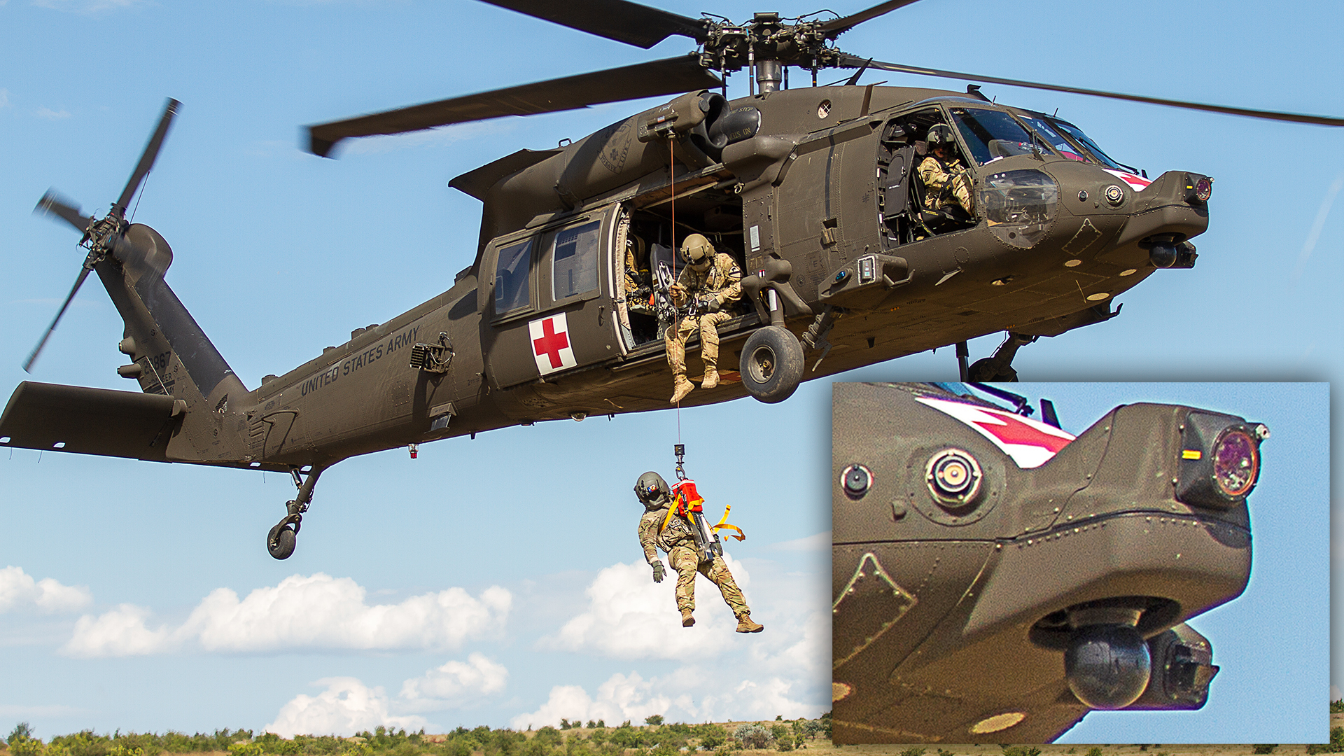
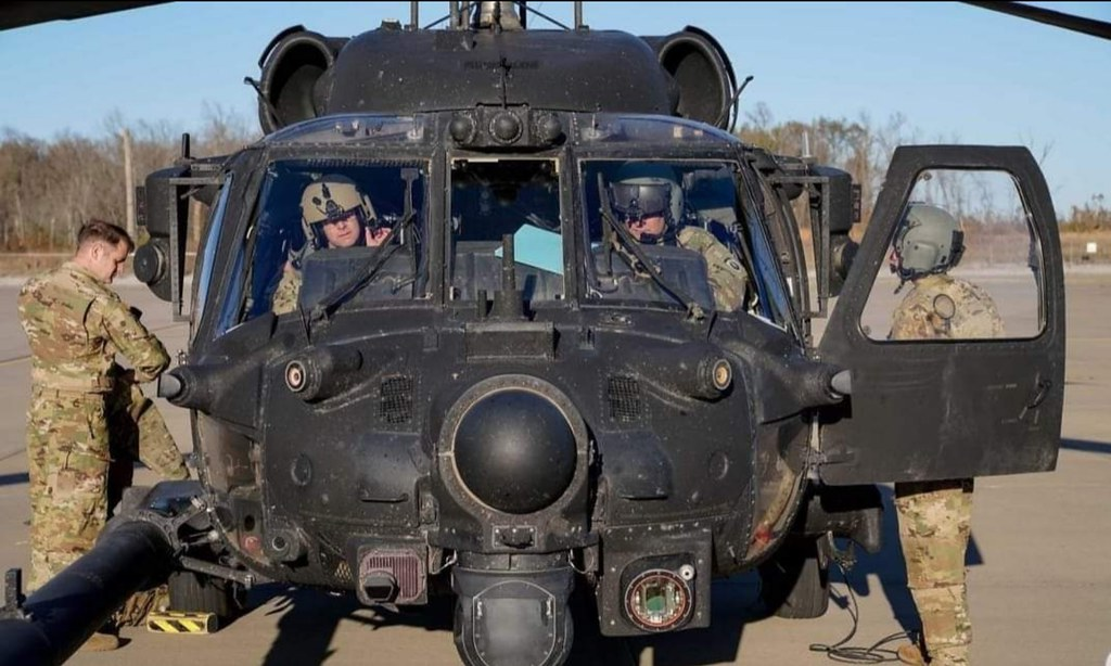
A U.S. Army medical evacuation helicopter participating recently in a joint exercise in Romania was seen with a new nose-mounted device that helps pilots see through dust clouds to land safely and locate wounded soldiers on the ground.
As seen in the photo at the top of this article, the HH-60M is equipped with the Degraded Visual Environment Pilotage System, or DVEPS, which is the uppermost, forward-facing sensor on the nose of the aircraft. A black gimbal below that houses a MEDEVAC Mission Sensor, which is a forward-looking infrared (FLIR) sensor turret. Together, the sensors are meant to help pilots fly through clouds of dust, sand, snow, and fog, collectively called degraded visual environments, as detailed in the video below from the U.S. Army’s Combat Development Command (DEVCOM) Aviation and Missile Center.
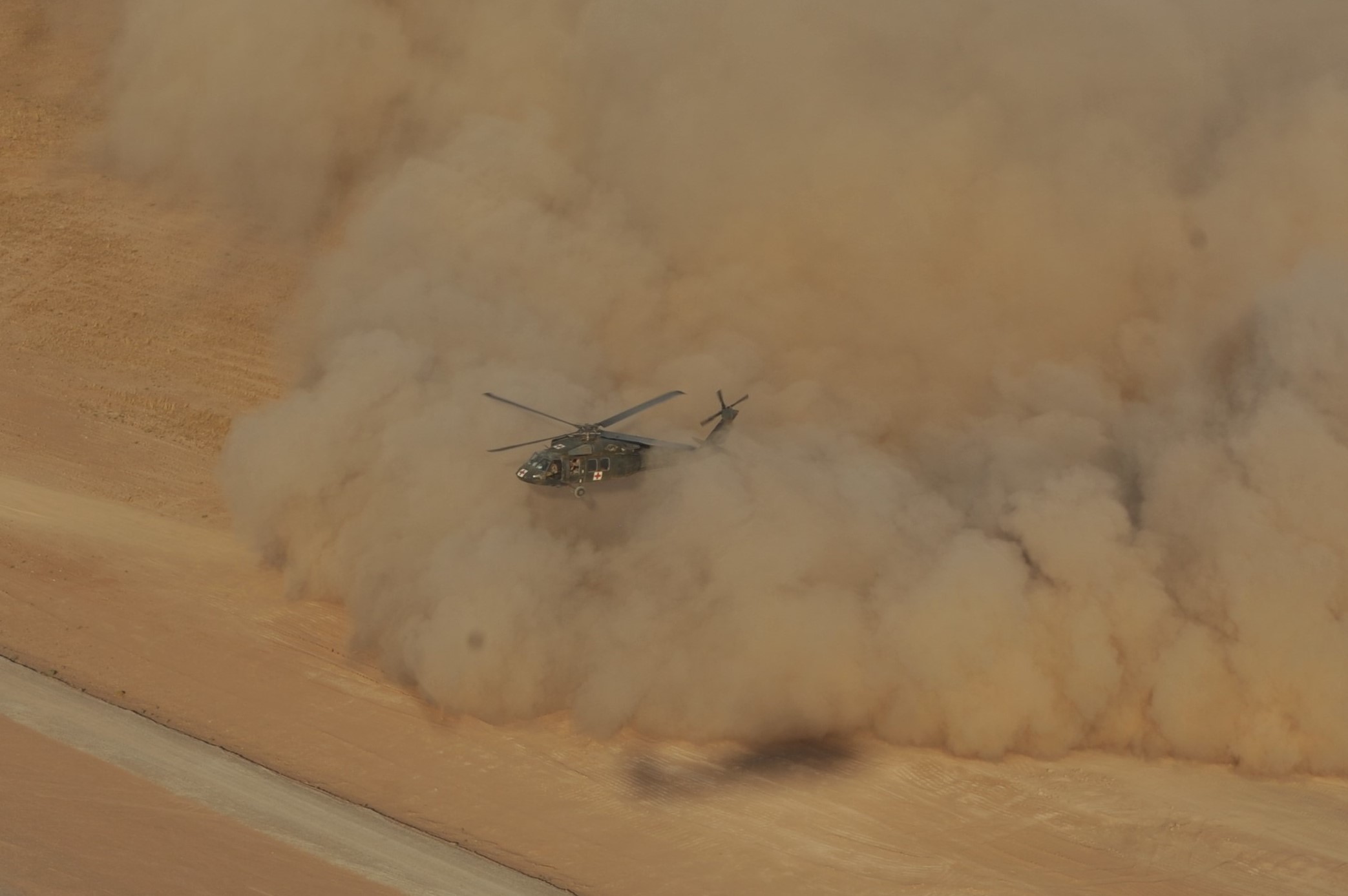
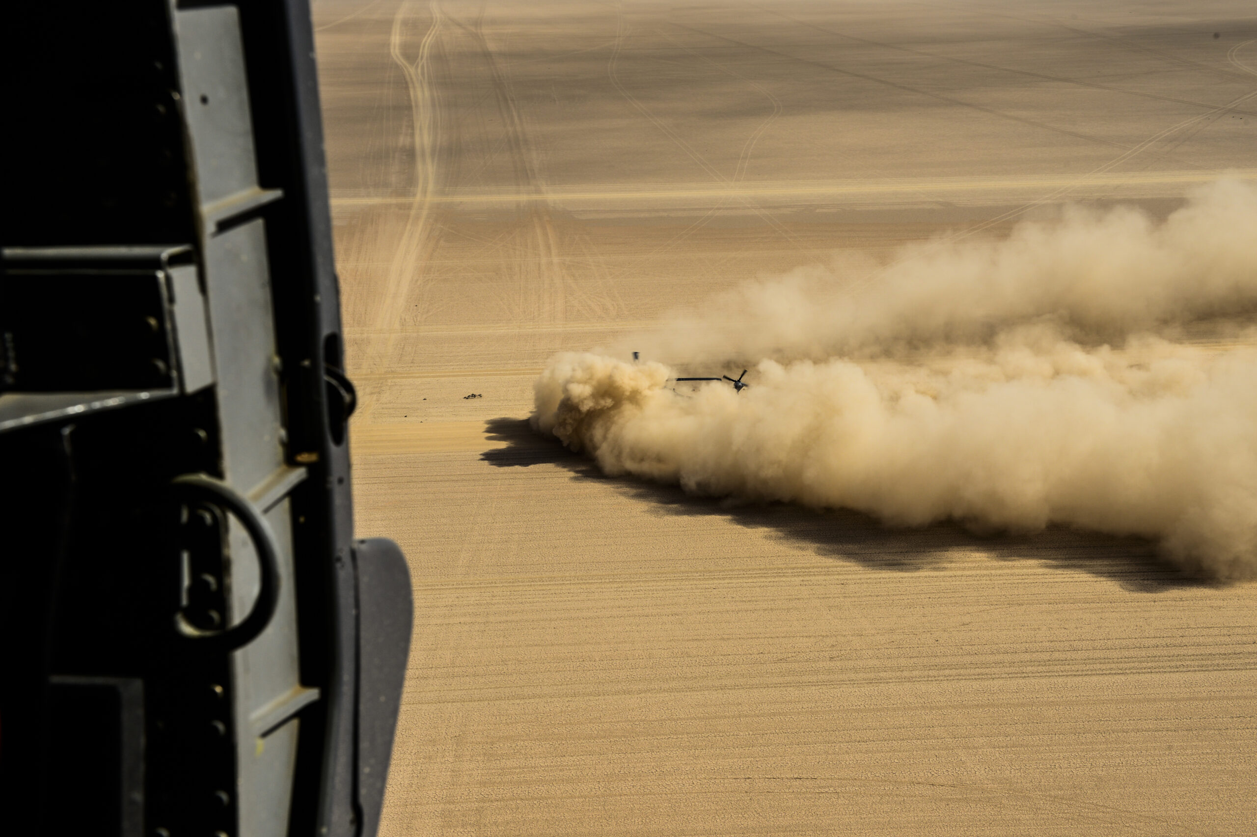
DVEPS is a situational awareness system equipped with a light detection and ranging, or LIDAR sensor, and long-wave infrared cameras coupled with a terrain database that provides pilots with a synthetic view of the world outside the aircraft through their helmet-mounted displays and cockpit screens. It provides 3D imagery of the ground and surrounding area through dust clouds and sand that are often kicked up by a helicopter’s rotor downwash when landing. Those conditions, referred to as a brownout, can blind pilots to their altitude above the ground and attitude, as well as to hazardous nearby obstacles like buildings, power lines, and vehicles.
Degraded Visual Environments (DVE) are a major challenge for rotorcraft pilots who must accurately gauge their height above the ground and keep an eye on nearby hazards while landing in austere, sometimes tight locations between buildings, in forested areas, or on uneven terrain. Medevac helicopters routinely fly into hazardous conditions to rescue wounded soldiers. They very seldom have the luxury of waiting for better weather to launch or choosing ideal, uncluttered landing zones. DVE conditions also disrupt a helicopter crew’s view of enemy troops around a landing zone.
The Army defines DVE as “reduced visibility of potentially varying degree, wherein situational awareness and aircraft control cannot be maintained as comprehensively as they are in normal visual meteorological conditions and can potentially be lost,” according to the DEVCOM. As visibility around a helicopter degrades, “aviation operations become more dangerous, less effective, and often impossible or deadly.”
DVE can be caused by aircraft but also can be environmental. Smoke from nearby fires, fog, snow, rain, and smog, among other environmental factors, can produce DVE conditions in which it becomes inherently more difficult and dangerous to fly.
“The system also provides an image of the LZ to assist in identifying the location of the patient and obstacles to extracting the patient in a quick and safe manner,” an Army Aviation spokesperson told The War Zone. Though it is called a “pilotage” system it is not currently intended to pilot the aircraft with any level of autonomy, but instead feed vital situational awareness information to human pilots, the Army spokesperson said.
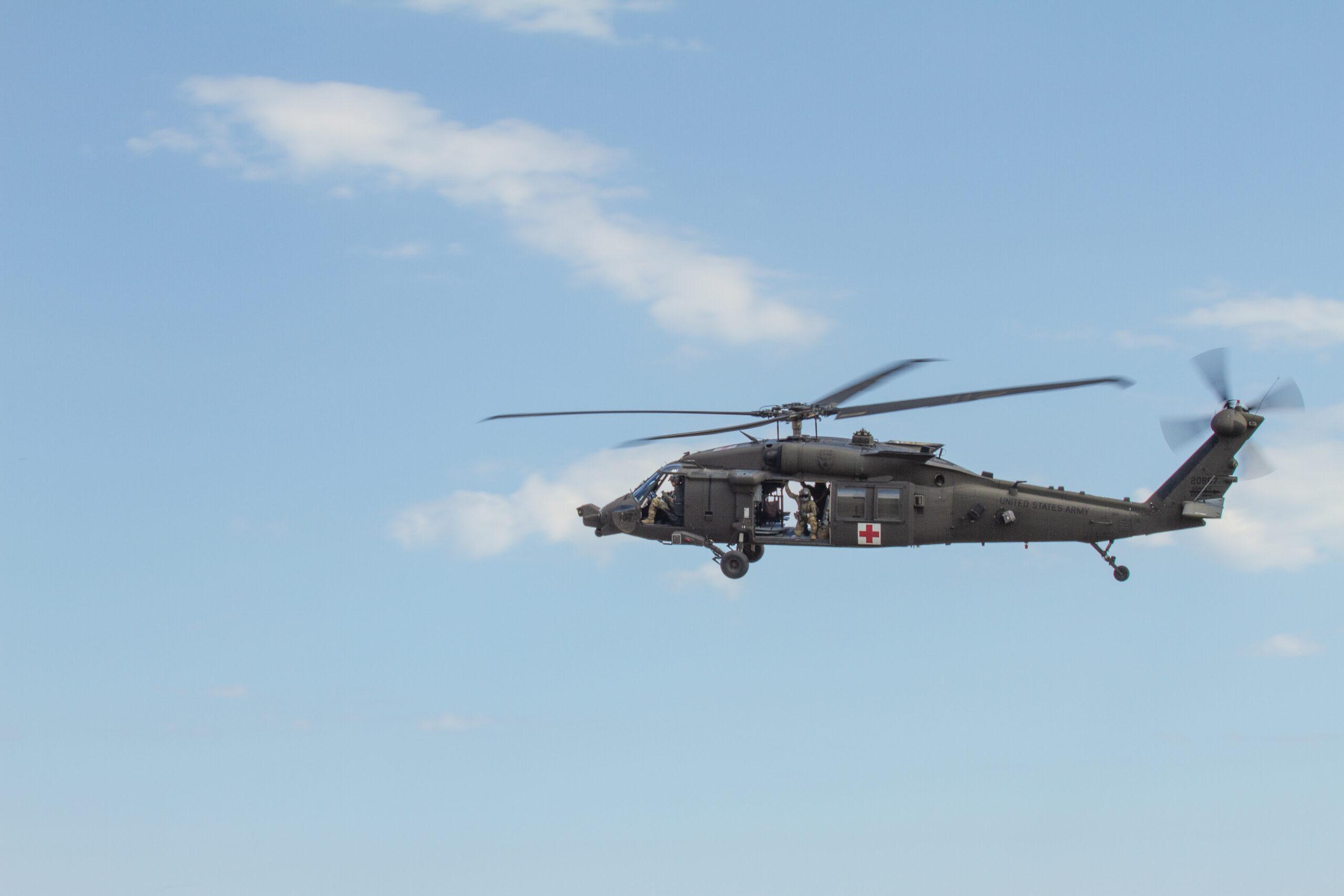
DVEPS were installed on 15 Army HH-60Ms in 2021 and they are now forward deployed in support of contingency operations, the spokesperson said. The helicopter seen in Romania was participating in personnel recovery training with the U.K. 140th Expeditionary Air Wing on July 12, according to captions accompanying the photos posted to the U.S. Defense Visual Information Distribution Service (DVIDS) website. Fortunately, the crew in Romania is practicing recovering wounded soldiers on a bright, sunny eastern European day, during which the DVEPS sensor suite is of less immediate use. That is not always the case, as Army rotorcraft pilots well learned landing in the dusty deserts of Iraq and Afghanistan for the better part of 20 years.
The DVEPS system was developed by Sierra Nevada Corp. under a contract awarded by the Army and U.S. Special Operations Command to provide pilots with a multi-sensor suite to help them maintain spatial awareness in DVE conditions. Brownout and other situations where pilots lose visual contact with their surroundings are a leading cause of accidents for both military and civilian aircraft. SNC’s DVE technology also provides terrain and obstacle awareness, including cable and wire detection, in limited visibility conditions.
“DVEPS offers a leap-ahead capability to enhanced situational awareness today and provides the foundation for an incremental growth path to a much greater capability such as pilotage or supervised autonomy,” said Greg Cox, executive vice president for SNC’s Electronic and Information Systems business area, said in 2015.
Rockwell Collins, now Collins Aerospace, also developed a DVE pilotage system for SOCOM beginning in 2013 that is compatible with both the MH-47G and MH-60M helicopters’ existing common avionics architecture system. That system integrates a synthetic vision avionics backbone (SVAB) system, which fuses 3D imagery with lightweight DVE sensors, including millimeter wave radar or LIDAR.
SOCOM’s 160th Special Operations Aviation Regiment (SOAR), nicknamed the Night Stalkers, first demonstrated a DVEPS system on an MH-60M in 2020 at Fort Campbell, Kentucky. Officials with the 160th said at the time they were “hopeful the technology fielded in Special Operations aircraft will one day be employed throughout the Army aviation enterprise to improve survivability and provide a better sight picture for pilots and aircrews operating in austere environments.” The system is mounted differently on the MH-60M, which you can see in the photo below, because its components have to contend with the helicopter’s terrain-following radar for space.
Rockwell’s system, like other companies’ DVEPS, produces fused 3D imagery, along with improved pilotage symbology provides pilots with a view of their environment, and visually overlaid flight guidance for en-route, approach and hover phases of flight.
Elbit Systems produces a similar DVE system called Brightnite. The video below is an excellent explainer on how the system works and what advantages it provides aircrews flying at night and in environments with restricted spatial awareness.

DVE mitigation technologies are aimed at both making flying in those environments safer, and turning them into a tactical advantage in which U.S. aviators can continue to operate with confidence, according to DEVCOM.
“The goal is to convert DVE into a combat multiplier by creating an advanced capability,” DEVCOM says in its published explanation of DVE mitigation efforts. “This will enable commanders to conduct deliberate operations in DVE with confidence that their crews will be safe and their missions successful.”
Sierra Nevada Corp. specifically touts its system’s applicability to faster, future vertical-lift aircraft the Army is currently developing.
Being able to see outside the aircraft and detect obstacles will become even more important when the Army introduces the Future Vertical Lift (FVL) family of advanced rotorcraft. Both the Future Long-Range Assault Aircraft (FLRAA) that will replace at least some of the UH-60 Black Hawks in the inventory and the Future Attack Recon Aircraft (FARA) that will assume an armed scout role, will be flown low and fast in contested environments to avoid enemy air defenses. For rotorcraft designed to fly at or above 200 knots at very low altitudes, obstacle and terrain detection equipment will be highly relevant technologies.
Contact the author: Dan@thewarzone.com
Loading comments…
Comments couldn’t be loaded. Please refresh the page.