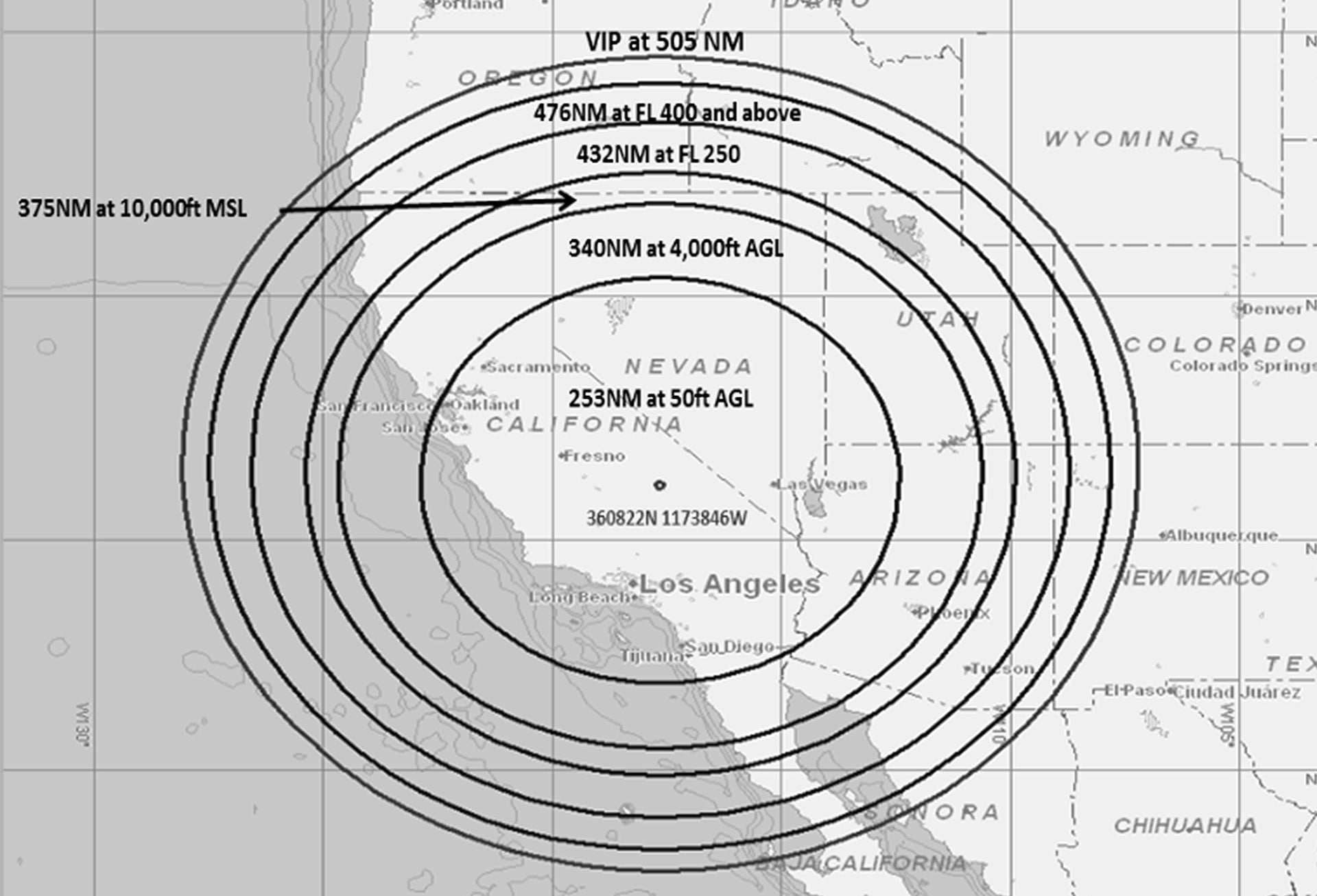
Picture a giant, invisible, upside-down cone rising up from the desert floor near Naval Air Weapons Station China Lake. It ranges over 500 miles in every direction, covers more than 500,000 square miles in total, and reaches up higher than any civilian aircraft can fly. Inside the cone, GPS-related systems fail to function.
That invisible cone will be a reality this month, at least intermittently, and the FAA is warning pilots that GPS-related systems may fail to work in the area over the next three and a half weeks (see flight advisory here).
Today, Gizmodo posted a story about the strange flight advisory and contacted Naval Air Weapons Station China Lake, which is one of the Pentagon’s multi-use test centers in the baking Mojave Desert, about the restrictions. Not surprisingly, the spokesman for the base couldn’t give any details as to what will cause such a widespread electromagnetic disruption, or why such a potentially hazardous series of events is being executed at all.
But we can infer some things from the nature of the FAA’s flight advisory. First, it’s not an airborne jamming system being tested, as the effective area and altitudes are indicative of an omni-directional emitter placed on the ground, with the curvature of the earth creating a line-of-sight blind cutout that increases in altitude with distance.
With this in mind, and noting that this emissions source has a high risk of jamming GPS signals, we can confidently hypothesize why such a scenario would be used for by NAWS China Lake testers.
The Defense Department is coming to terms with its acute addiction to GPS. Navigation on sea, in the air, and on the ground all largely rely on GPS. Many weapon systems, like cruise missiles and GPS-guided bombs, also rely on the technology, at least partially, to hit their intended targets reliably and accurately.
These systems are largely paired with inertial navigation systems, so that if GPS is not available or degraded during flight, they can still find their final destination. (You can read all about INS with embedded GPS here.) But the reality is that, if the GPS lights go out so to speak, our fighting forces would be severely crippled. The enemy knows this, and our GPS satellites can be attacked in multiple ways, both kinetic (anti-satellite weaponry, orbital tampering, etc.) and non-kinetic (jamming, hacking, etc).
C4ISRNet.com executed an incredibly succinct interview with the head of the Navy’s Communications and GPS Navigation Program Office, Captain Mark Glover. In the piece, the Captain described the military’s dependence on GPS:
“As you know, GPS is ubiquitous. There is an increasing reliance on GPS across all ranges of military operations, and, of course, we can’t forget our critical civilian infrastructure as well. Additionally, GPS jammers have proliferated around the globe, from large and complex militarized jammers to cheap and inexpensive units you can buy online. That means that not only that our peer and near-peer potential adversaries are capable of impacting GPS, but we must be mindful of non-state actors, as well.
Furthermore, we are trying to predict other methods that might be employed against our systems, such as cyber threats. Because it is not just a threat against the radio frequency signal, it is a threat against the actual systems that control those. Over the past 20 years, GPS has been a force multiplier for our military. But we cannot assume that any longer. We have to be proactive in protecting this valuable resource.”
The Captain continued, discussing the challenges presented by a GPS degraded combat environment:
“Let me put a little context on top of it. The GPS satellite signal at a user’s antenna is very low power. To put that in perspective, a 100-watt bulb is [10 to the 18th power] more powerful than a GPS satellite signal at the receiver’s antenna. A low-power jammer can disrupt GPS operations.
To that end, denial and degradation of GPS can have myriad effects on our systems. Without protection, our ships, submarines and aircraft won’t be able to properly navigate. Some of our sensors might not function properly, and provide erroneous information to our war fighters. Plus, time and frequency is a critical part of our communications infrastructure. Disruption of time can prevent those networks and communications systems from functioning properly, as well.”
With all this in mind, the Department of Defense is coming up with new concepts, and dusting off old ones as well, to deal with a GPS-denied reality. On the low end, one measure once again sees the Navy teaching and practicing celestial navigation. On the higher end, and initiative called Assured Positioning, Navigation, and Timing (Assured PNT) looks to explore, and eventually leverage, a series of potential antidotes to the idea of fighting without GPS. A group of these technologies could be part of an entire ecosystem of resilient navigation and timing capabilities used by multiple platforms and weapon system that will be able to fight in future wars where GPS is not a certainty.
By distributing multiple types of navigational aids and sensors throughout the battlespace and across many platforms, and even linking them together, highly accurate positioning could exist without relying so heavily on GPS. This “cocktail of solutions” concept also means high-quality timing and navigation is resilient, as it’s not based on just a single solution. As such, Assured PNT won’t simply addict the Pentagon to another vulnerable, blanket navigational concept, like GPS.
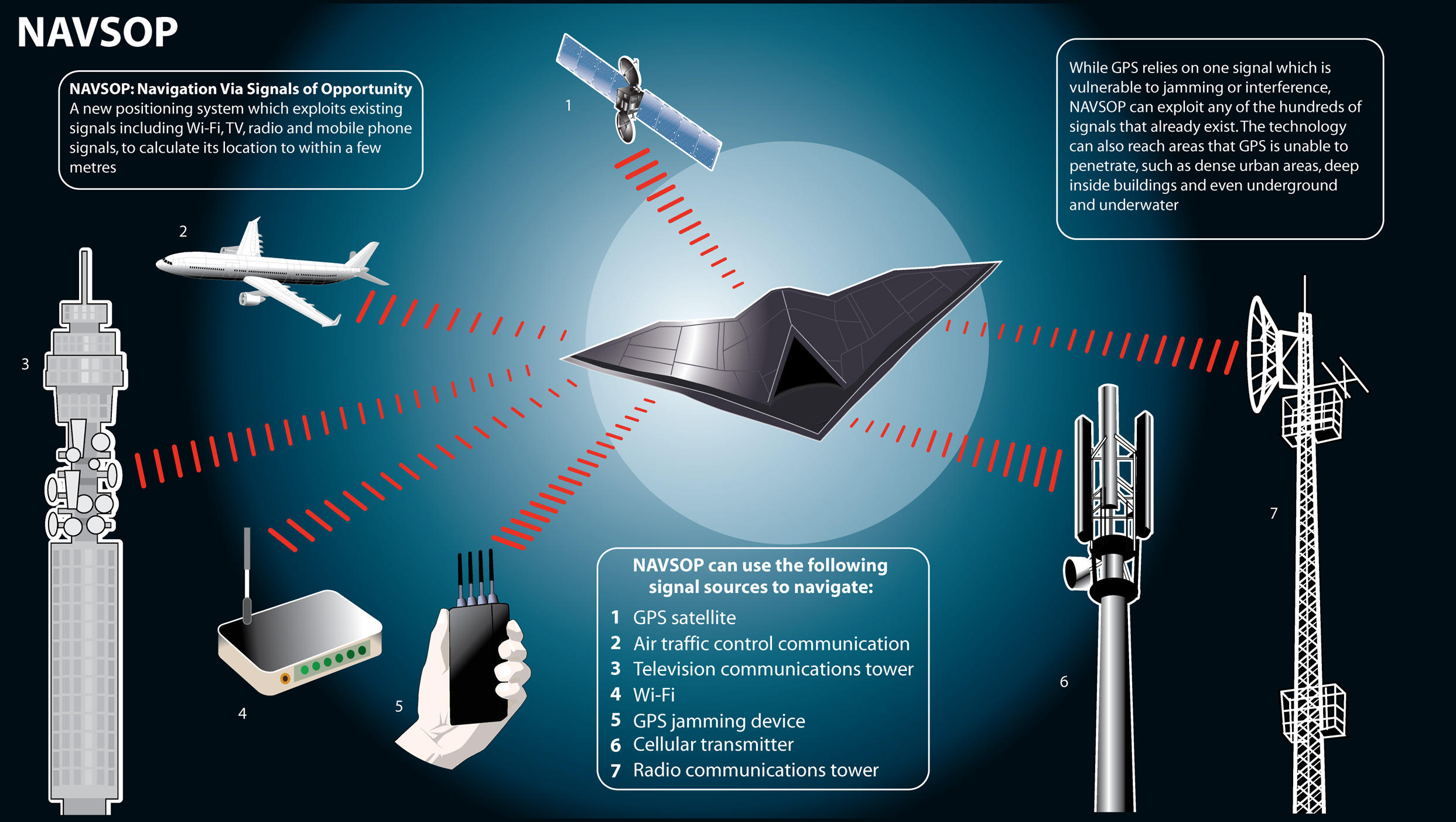
Part of this new initiative includes developing Inertial Navigation Systems that are more accurate than their predecessors, and also more inexpensive and compact so they can be easily deployed across the battlefield. Another technology being developed by BAE Systems, dubbed Navigation via Signals of Opportunity (NAVSOP), uses the electromagnetic waves all around us, from sources like television and cell phones—and even GPS jammers themselves—to provide positioning information passively. This is an especially attractive set of features for stealthy aircraft that need to stay as emissions-silent as possible. Miniaturizing atomic clocks and making them more accurate is another partial solution.

Basically, the Pentagon is shopping for an answer, or a series of answers packaged together, for this major problem. Obviously, defense contractors want to be part of the solution and the gravy train that will go along with it.
Brand-new ideas are not the only relevant ones out there; sometimes, using what you already have but in a more automated fashion may at least be a fallback solution. For instance, fighter and attack aircraft have radars that can map the ground with great precision. By matching snapshots of the terrain around them with geo-spatial imagery loaded into an onboard memory bank, the aircraft could automatically increase the accuracy of its INS-reliant navigation system, which, traditionally, is not highly accountable for detecting things like drift. Even using a fighter or bomber’s targeting pod’s laser rangefinder and “squirting” at different known landmarks on the ground can enhance the aircraft’s navigational accuracy when GPS is unreliable.
The truth is that even cruise missiles, which have to be very accurate in order to accomplish their singular task, were put to work for many years without the use of GPS. It wasn’t until Operation Secret Squirrel in 1991 that GPS became a part of the cruise missiles’ brains. Before that, terrain contour matching (TERCOM) and INS were effective ways to navigate to their final destinations.
When you consider all of this, you can see how ominous of an idea a GPS-less war is becoming within the Pentagon’s collective brain. As such, concepts like those described above, and the very weapons and aircraft themselves that rely on heavily on GPS today, all need to be tested in a GPS-denied scenario. Yes, tests can probably be simulated to a large degree, but testing under real-world conditions, over a wide area, is certainly necessary to prove key theories and predictive models—and to further validate less ambitious tests where GPS denial or degradation was only simulated.
There is the possibility that this event is being caused by some other exotic test that just so happens to jam GPS signals as a byproduct, but that’s highly unlikely. Even the idea that we’re testing our own GPS-denial weapon system is possible, but this could be done alongside a test for the umbrella objective of being able to fight in such an environment.
So there you have it. NAWS China Lake, which does a sizeable portion of its work under the shroud of secrecy, is likely doing absolutely critical work when it comes to ensuring our combat capabilities are not gutted due to the loss of a single capability—GPS. The Navy would not cause such intense series of potential disruptions over such a large timescale unless the testing was of extremely high importance, and figuring out how we can continue to vanquish our enemies without the help of navigational satellites is certainly that.
Contact the author Tyler@thedrive.com
