Our account and its accompanying gallery of private pilot Gabriel Zeifman’s somewhat astonishing flight through the usually highly restricted Nevada Test and Training Range (NTTR), which includes shadowy bases like Area 51 and Tonopah Test Range Airport, and the Nevada Test Site, where hundreds of nuclear weapons were tested, drew fascination from readers all over the globe. Now Gabriel has shared additional images of his adventures over the NTTR that are pretty spectacular in their own right and they include the best photos I have seen of a very popular location in UFO lore, Papoose Lake. Located just to the southwest of Area 51, this is the place where Bob Lazar claims of having reversed engineered flying saucers in the 1980s while working inside a camouflaged facility called S-4 that was built into the side of a mountain.
No, I don’t believe Bob’s story, but I do think that it is one of the most entertaining tales ever told and it has continued to capture imaginations for decades. I wasn’t thinking of Bob Lazar or “S-4” when I wrote my story on Gabriel’s flying adventure, but after I published it, I was swarmed with emails and direct messages asking if he had any pictures of Papoose Lake. Aside from satellite images, no direct photos of the area in question are known to exist, that is until now.
The most impressive part of his route through the NTTR was the turn to the west, just south of the infamous impenetrable “box” of airspace that surrounds the clandestine flight test facility located at Groom Lake. This part of his flight took him directly
over Papoose Lake and the hill that Lazar famously claimed had camouflaged hangar doors built into the side of it to hide from 1980s imaging satellite technology. Although Gabriel didn’t take any pictures of this area on the flight we discussed in our previous article, he did on a previous excursion with a less capable camera.

For purposes of continuity, we have laid out a selection of Gabriel’s images in order of how his flight progressed around and through the NTTR. Beyond Lazar’s supposed UFO reverse-engineering lair, there is plenty more to see, including another shadowy base that is located near the Department Of Energy’s Yucca Lake facility. That drone test base has a big new hangar facility. We also see the various targets in different range areas spread throughout the NTTR’s central and southwestern reaches, one of which is quite elaborate.
We will start off our journey near Lida Junction, Nevada, where a lakebed has a huge humorous inscription drawn in it for those flying over to read. Then, just like last time, Gabriel enters the normally closed airspace—you can read all about how private light planes occasionally get totally legal access to it in our previous piece—just to the north of Tonopah Test Range Airport. You have already seen the amazing photos he took on his latest journey through the area of this base—the historic home of the F-117, America’s secret MiG squadron, the RQ-170, and who knows what else. He then drops down into the central range areas from there, circumventing Area 51 and crossing over Papoose Lake, and heading into the southern reaches of the huge complex.
With all that said, here we go:
Whoever drew this massive “UFO” and arrow on this dry lakebed northeast of Lida Junction, Nevada, right on the western edge of the Nevada Test and Training Range (NTTR), clearly wanted flyers by to know “the truth was out there”:


The Tonopah Test Range Airport:

A broad view of the Tonopah Test Range (TTR). A dry lake bombing range inside the TTR, which has been used to test inert nuclear bombs, is seen, as are the living facilities that are used for Tonopah Test Range Airport. They were originally built for the F-117 program when it existed at Tonopah in total secrecy:

Gabriel’s GPS showing him approaching the R-4808N restricted area:

Keno Airstrip within the R-4807A restricted airspace, at the northern edge of the NTTR, is sometimes used by the Air Force during its Red Flag air combat exercises and its Joint Forcible Entry Exercises (JFEX):

A bombing range in the Kiwich Valley, just to the east of Area 51’s northwestern corner:


Another target area, this one representing an airfield, just to the south of the one on the dry lakebed:

Groom Lake and the Area 51 flight test center located there seen as Gabriel passed along the northern edge of its closed airspace:

Gabriel’s plane parked along the road outside the Little A’Le’Inn. This is a frequent haunt of those looking to get close to Area 51 on the ground and situated on Extraterrestrial Highway, also known as Nevada State Route 375, in Rachel, Nevada:

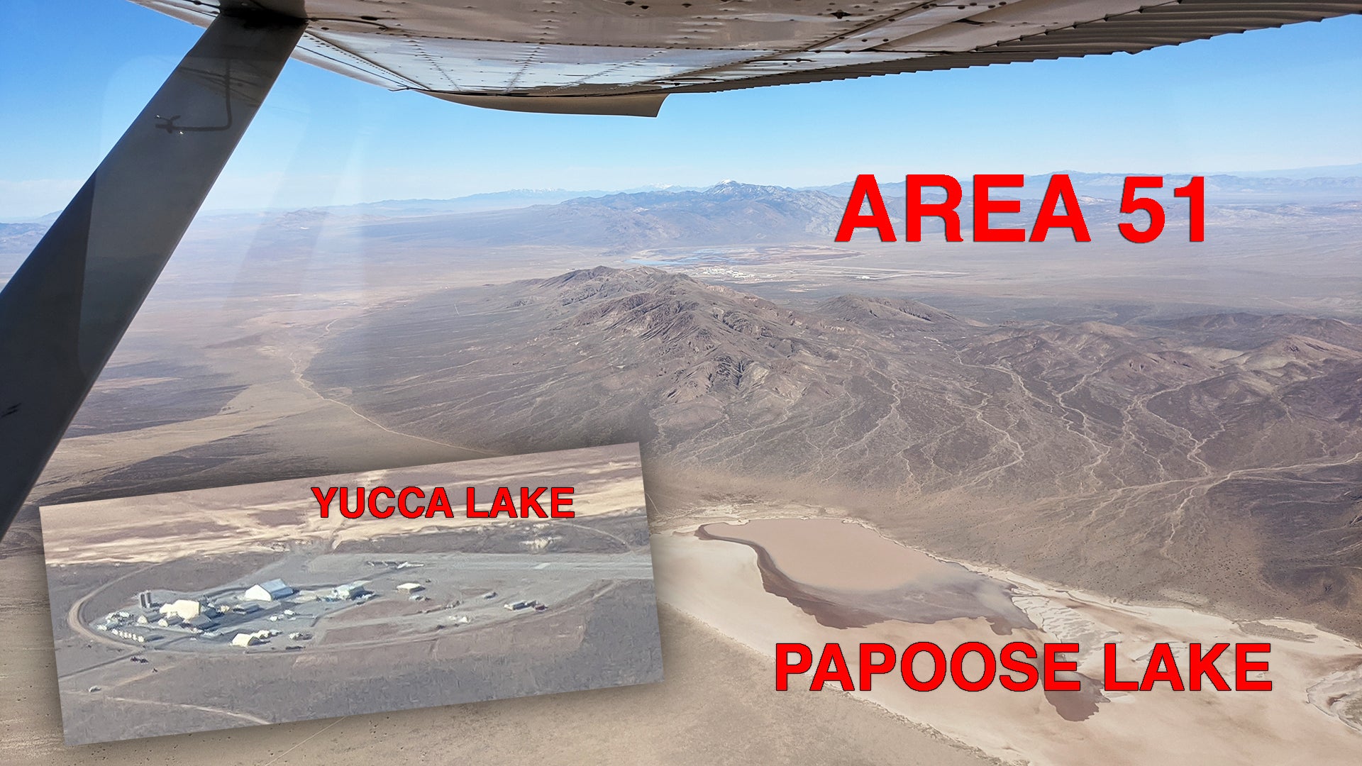
Below are shots of Papoose Lake with Area 51 just over the Papoose Mountain Range. Unsurprisingly, nothing appears to be there, just as satellite images show. There isn’t even an access road and, as you can see, the lakebed is flooded, which is a fairly common occurrence, making traversing it in a car or bus problematic. Regardless, it is a fun little pop-culture element to the story and for many, it will add to the evidence that Lazar’s story is a fake, albeit remarkably elaborate tale, and for the believers, it will probably do the opposite, somehow.


Lazar did play a huge part in turning Area 51 into a household name, for better or worse, and he did seem to know a lot about the base itself—the one that actually exists—for the pre-internet era. He has even made claims about seeing a high-speed exotic aircraft on the base while transiting to the remote UFO shop at S-4. Here is his drawing of that craft:

Although some of the details Bob mentioned about the base and its operations proved to be accurate, that doesn’t mean he worked on alien craft at some comic-book-like hideout facility built into the side of a mountain at Papoose Lake. The NTTR is a huge place, with big stakeholders like the Department of Energy and the Air Force operating an endless list of facilities out there, as you can see in these pictures. As such, it employs all the same types of people you would need for similar unsecured areas, including electricians, security personnel, janitors, cooks, engineers, computer techs, construction workers, and so on. So yes, you can work out there without reverse engineering UFOs or test-flying secret stealth aircraft.
After that little detour into the bizarre, we continue our flight…
An area of the Yucca Flat, north of Yucca Dry Lake, within the Nevada Test Site, now known as the Nevada National Security Site, which is heavily pockmarked from underground nuclear testing during the Cold War:


A view of the secretive airstrip at the southeastern edge of Yucca Dry Lake, within the Nevada National Security Site’s Area Six, that is used to support unmanned aircraft test and evaluation activities for the US military and other US government agencies, including the CIA. You can read our report on this facility here. You can also see the DOE’s fortress-like Device Assembly Facility to the far left.


You can see the big new semi-permanent hangar that has been erected on the facility’s main apron:

A view of Frenchman Dry Lake and the adjacent French Flat within the Nevada Test Site, which were the sites of numerous above-ground nuclear tests at the dawn of the nuclear era:

The view of the northern end of Dog Bone Lake, which sits in a part of the NTTR’s airspace designated R-4806W. The southern end of the lake bed serves as a gunnery and bombing range and has a MOUT facility that is regularly used for JTAC training, as well as other exercises where air and ground assets work together:


Looking west at the very southern end of the NTTR. Creech Air Force Base is in the distance:


Here is our best approximation of where the images were taken:

Although we weren’t able to positively identify any secret UFO workshops hidden in mountainsides, these are some very rare images of an incredibly shy section of the American Southwest. A big thanks to Gabriel Zeifman once again for sharing the images from his airborne journey with us.
Contact the author: tyler@thedrive.com