Located 40 minutes outside of the busy city center of Catania, on the Italian island of Sicily, Naval Air Station Sigonella has become arguably the most important facility for NATO’s Alliance’s Ground Surveillance force. Since 2017, the AGS Main Operating Base has been located at Sigonella and is now also home to five high-altitude, long-endurance (HALE) RQ-4D “Phoenix” drones, which are actively being used by NATO to conduct reconnaissance missions near Ukraine.
AGS pilots, joint intelligence surveillance reconnaissance (ISR) analysts, sensor operators, and maintainers have all been undergoing training at the base as part of the initial steps to create a “Premier NATO Training Center” in the Italian region. According to NATO, Sigonella is expected to see the completion of AGS permanent facilities later this year, and once fully operational, the center is set to host 22 training instructors (mission crew and pilot trainers) which, with the help of a simulator, will be capable of handling 80 trainees annually. This will represent not only a critical boost in the ISR capabilities of the alliance alongside its eastern flank, but it will also prove to be a key milestone for Italy’s military standing internationally.
Phoenix Rising
The development of a NATO-owned and operated high-end aerial reconnaissance capability dates back to 2012, when a procurement contract was awarded for the funding and delivery of the Northrop Grumman RQ-4D AGS system, whose capabilities would be made available to all member-states. Included were the acquisition as well as initial operation and maintenance of the remotely piloted aircraft, with the overall costs covered by the alliance.

Once NATO allies decided to procure the system, Italy offered to host the AGS Main Operating Base at Sigonella. The U.S. Air Force RQ-4A Global Hawk, on which the AGS is based, is also located at the base, allowing for greater synergies in logistics, operations, and sustainment. Hence, it was agreed that the RQ-4D drone would be kept, controlled, and operated by AGS pilots at the Italian Air Force Base, which simultaneously became NATO’s Joint ISR deployment facility.
While a large number of AGS members are based in Italy, there are also a number of personnel coordinating missions at the Allied Command Operations in Belgium and at the Headquarters Allied Air Command in Ramstein, Germany.

The first flight remotely controlled from Sicily was conducted in 2017, with the drone reaching Initial Operational Capability (IOC) in February 2021. According to a NATO official speaking to The War Zone, “since October 2021, the force – out of its Sigonella base – has flown many missions and generated over a thousand products supporting NATO’s intelligence operations in assessing developments in and around Ukraine.”
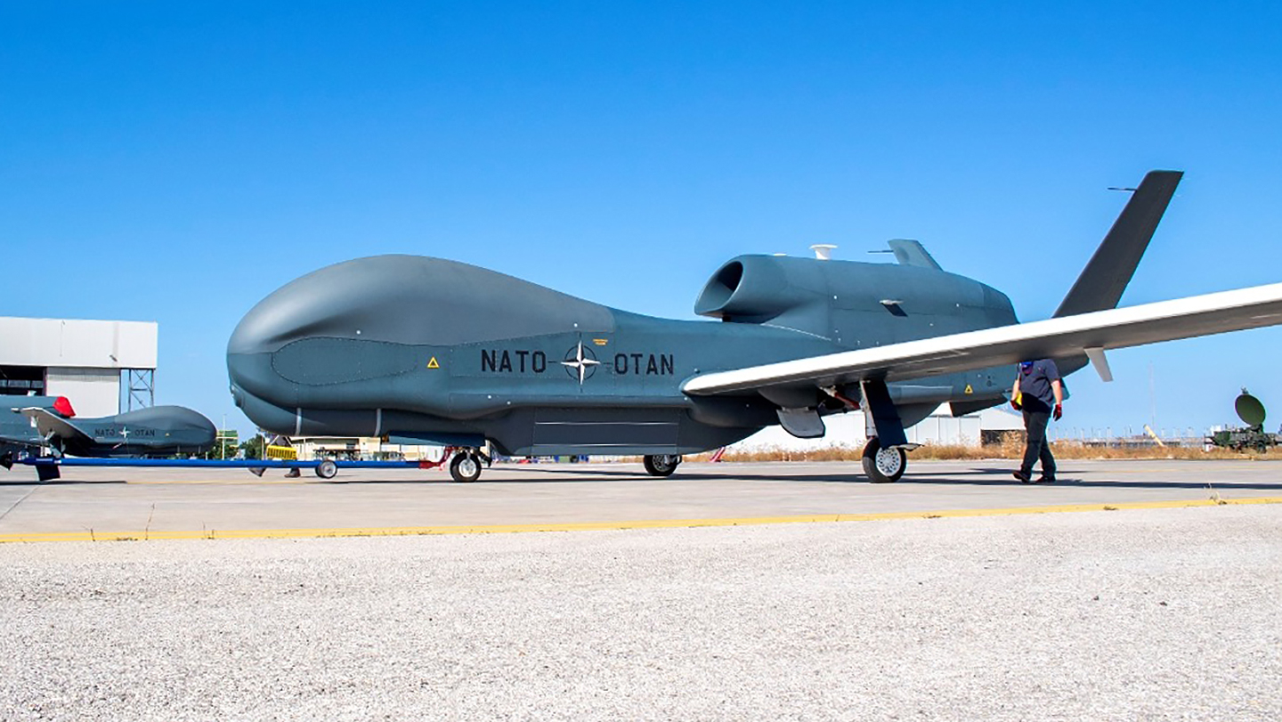
Today, the AGS system includes five identical RQ-4Ds that are jointly owned and operated by NATO and were delivered by a consortium of leading industries from 15 countries having taken part in its procurement process – including Germany, the U.S., Denmark, Luxembourg, Latvia, Norway, Romania, Slovakia, Estonia, Poland, Bulgaria, the Czech Republic, Lithuania, and Slovenia.

European manufacturers were specifically chosen to develop the drone’s mission operation support systems and provided the transportable and mobile ground stations to assist deployed units as well as remote command and control workstations. The platform, which can fly for roughly a day and a half at a time and can reach altitudes of 60,000 feet, is derived directly from Northrop Grumman’s RQ-4B Block 40 Global Hawk. They are both equipped with the extremely capable Multi-Platform Radar Technology Insertion Program (MP-RTIP) sensor. However, the NATO official who talked with The War Zone points out that “there are differences between both, primarily in the radar system architecture and communications suite as well as the ‘cockpit,’ where NATO’s RQ-4D [drone] incorporates advances from U.S. Navy Triton remotely piloted aircraft.”

Regarding NATO’s decision to choose the RQ-4D, the representative added that it was the drone’s advanced ground surveillance radar that was the decisive factor, which was also modified to fit NATO requirements. As part of the platform’s unique sensor package, it has an active electronically scanned array (AESA) radar that can work in Synthetic Aperture Mode, or Ground Moving Target Indicator (GMTI) modes. The first takes photo-like radar ‘images’ over great distances and in any weather of areas of interest, while the latter tracks vehicle movements over broad areas. Combined, they can paint a very compelling picture of the disposition and movement of enemy forces as well as collect more targeted intelligence on specific locations. The RQ-4D also possesses a large suite of long-range line-of-sight and beyond-line-of-sight data links to send its information where it needs to go and for command and control purposes.

General characteristics of the NATO RQ-4D remotely piloted aircraft:
- Primary function: High-altitude, long-endurance intelligence, surveillance and reconnaissance
- Power plant: Rolls Royce-North American AE 3007H turbofan
- Thrust: 7,600 lbs
- Wingspan: 130.9 ft / 39.8 m
- Length: 47.6 ft / 14.5 m
- Height: 15.3 ft / 4.7 m
- Weight: 14,950 lbs / 6,781 kg
- Maximum take-off weight: 32,250 lbs / 14,628 kg
- Fuel capacity: 17,300 lbs / 7,847 kg
- Payload: 3,000 lbs / 1,360 kg
- Speed: 310 knots / 357 mph / 575 kph
- Range: 8,700 nautical miles / 10,112 miles / 16,113 km
- Ceiling: 60,000 ft / 18,288 m
The in-flight information gathered by the drone is directly sent to the AGS Force Processing, Exploitation, and Dissemination (PED) center at Sigonella, where a multi-national team of analysts processes the data to provide imagery intelligence exploitation. The Sigonella PED center allows for quick dissemination of the data to all 30 NATO countries including NATO headquarters. This includes near-real-time forensic exploitation to support targeting, on-demand 24-hour operations, and available PED nodes to help tactical commanders. Acquiring its own high-altitude, long-endurance (HALE) ISR drone and PED nodes has proven especially helpful for NATO, as it no longer has to rely on other countries for gathering this type of intelligence.

The Ukraine Context
Between May 11 and 18, NATO announced that it had successfully concluded what it coined a “surge week,” consisting of launching an RQ-4D aircraft every other day from Sigonella, operating at 50,000 feet along its eastern flank. The overall number of hours flown over the course of that week was said to have been more than what the AGS accomplished during a two-month period in 2021.
More specifically, the Alliance reported that on May 15, one of the NATO drones flew an unusually long surveillance mission above the Black Sea and the Baltic Sea. Using the Phoenix’s SAR and MTI capability, it transferred the collected images and data directly to Sigonella AGS units, which Brigadier General Houston Cantwell, Commander of the ASG Force said, “most certainly supports NATO’s strategic decision-makers by providing valuable information on the Ukrainian situation and by bolstering the Alliance’s defensive posture along the eastern flank.”

In terms of its survivability, the NATO official claims that the Phoenix’s ability “to fly high at a loiter altitude of above 50,000 feet helps minimize its exposure to enemy weapon engagement zones.” Additionally, the fact that the aircraft is equipped with a very powerful AESA radar provides it with several advantages. This system allows for the radar to operate across a wide range of frequencies in different directions with every pulse, meaning that it makes it harder for adversaries to pull the radar’s signal out of background noise.
Regardless, just before Russia invaded Ukraine, NATO surveillance aircraft stopped flying routes over the country. Instead, they now operate along the borders of Ukraine in friendly airspace or in international airspace over the Black Sea, drastically lowering their vulnerability to enemy attacks and any avenue for Russia to declare them viable targets. While standoff surveillance is what the AGS was specifically designed to do, this change has limited its ability to provide intelligence on some collection areas.

Among the key challenges these drones have had to face is the overall size of the area of operations – the distance between Ukraine’s western border with Poland and its eastern frontier with Russia stretches over 404 nautical miles. Although the RQ-4D’s exact radar capabilities are classified, some open sources suggest that their capabilities decrease at distances over 270 nautical miles and simple physics states that even at 60,000 feet, radar line of sight drops off not too much farther out. Such range limitations have likely made it significantly difficult to monitor Russian troops in the eastern part of Ukraine (i.e. Kharkiv and the Donbas region). These constraints also explain why the aircraft are primarily flown above the Black Sea or the border regions near Belarus.
When it comes to reaching its stations, currently, two different corridors exist for the RQ-4Ds to reach the Black Sea. One of these airspace corridors is over Greece and Bulgaria (or alternatively, Romania) while the other one is above Germany, which the German Ministry of Defense recently approved.)
Building NATO’s Premier Drone Training Center
The NATO official confirms that, overall, the AGS has an authorized maximum force of 599 personnel. Just under 400 personnel are currently assigned to it at Sigonella. Among these, Germany is reported to have contributed 88 people to the force and has deployed three pilots to the Italian center (wanting to train 14 overall) alongside Canadian, American, and Italian pilots. A multi-national pool of approximately 20 pilots in total has thus far been trained to operate the RQ-4D aircraft.

Although Sigonella is under the military and administrative control of Italy (being home to the Italian Air Force’s 41º Stormo anti-submarine warfare wing), it has also been a major hub for U.S. naval aviation operations for decades. In total, outside of the U.S. Navy installation, it hosts over 40 American commands and activities, including a contingent from the USAF’s Air Combat Command. As such, the U.S. is currently operating at least two Global Hawk drones from Sigonella, along with Reapers and manned aircraft.

Aircraft trackers have reported that the U.S. Global Hawks have at least performed one ISR mission alongside NATO’s Phoenix drones over and near Ukraine. Rationing assets to maintain as much continuous time and station likely make this something of a rare occurrence. From the Italian base, America has also been carrying out maritime patrol missions over the Eastern Mediterranean and the Black Sea with its Boeing P-8A aircraft.
Since the early days of the Ukraine conflict, NATO allies have continued their daily ISR coverage of Russian troops, nearing 24/7 continuous activity. Such an operational pace has not been seen for several years and is likely to be maintained over the coming months as the conflict continues to evolve.
With NATO’s decision at the 2022 Summit in Madrid to enhance multinational land battlegroups from battalions to brigade size in its Eastern flank, the completion of the Alliance’s first Premier Drone Training Center in Italy will further ensure the development of its air and intelligence-gathering capabilities. By hosting these critical facilities, it will take Italy’s title as “NATO’s aerial anchor” to the next level.
Contact the editor: Tyler@thedrive.com