We are excited to announce the launch of our new interactive tool that maps and makes searchable thousands of unmanned aircraft system (UAS) and unidentified aircraft incident reports. The vast dataset is drawn from information compiled by the Federal Aviation Administration. Some of the reports are highly unusual, going far beyond typical low-altitude drone mishaps.
To our knowledge, this is the first attempt to make a publicly available system that can both seamlessly search and map these incidents. Though the data in the reports is often cursory, it provides a mechanism to identify and further investigate significant incidents and to interpret broader trends.
A growing problem
UAS incidents with manned aircraft have become increasingly commonplace in recent years, with some posing significant aviation safety and national security concerns. The term UAS is used to convey a wide variety of aircraft, including rotary and fixed-wing drones as well as balloons and less clearly identified types.
The War Zone has covered a number of high-profile UAS incidents. For example, earlier this year a “highly modified” drone in Tucson penetrated controlled airspace, leading to a prolonged helicopter chase and no success in identifying the operator or the high-performance drone type. Drones have also become a significant issue for nuclear reactor safety, including a still unresolved incident involving multiple drones descending on the nation’s most powerful nuclear reactor in Palo Verde, Arizona.
The issue has also significantly impacted the military. The War Zone covered an incident that involved a large number of drones apparently harassing Navy vessels near Southern California. Our subsequent investigation of FAA records surfaced nearly two dozen other reports of unusual UAS activity near military facilities or aircraft. These new records come in addition to exclusive past reporting on aviation safety hazards off the East Coast and similar records released by the Air Force.
The UAS issue has in many ways converged with an ongoing national discussion on “unidentified aerial phenomena” or UAP. The Office of Director of National Intelligence recently released a long awaited report on UAP that prominently cited the importance of FAA data in resolving unidentified aircraft sightings. The UAPTF report acknowledged that some reports may be attributable to foreign adversaries, though there is no direct evidence of such at this time. The War Zone has explored the potential connection between UAP sightings and UAS at length.
The Data
The original FAA data consists of approximately 10,400 incident reports published online via a number of Excel spreadsheets. The FAA offers few details about how the reports are collected, or how they are ultimately selected for this public dataset. A significant number of the summaries involve references to Mandatory Occurrence Reports (MOR), an FAA process designed to capture a wide array of information about aviation safety incidents. According to FAA regulations, a MOR must be generated whenever a pilot reports “unauthorized UAS activity or authorized UAS activity that is conducted in an unsafe or hazardous manner.”
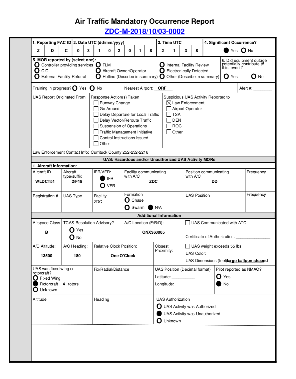
Example FAA Mandatory Occurrence Report
, Federal Aviation AdministrationThe UAS Sightings Report data span from November of 2014 until December 2020. We have standardized and joined these spreadsheets together into one consolidated resource. Although the reports do not include precise location information, we have been able to assign approximate locations using the city and state information provided. Importantly, we have introduced a small amount of randomness to the locations in order to prevent the incidents in the same city from overlapping each other on the map. Please note that the location on the map does not correspond precisely to the location of the incident. In fact, based on our previous reporting, we have found that the actual location of the incident can be many miles from the city cited in the report.
Further, there are a large number of spelling errors and other issues in the original data, so not all locations have been matched to date. Currently, our mapping system has geocoded 9566 reports. We are working to resolve the location information on the remaining reports.
We have also implemented a tool to extract the approximate altitude of the incident based on the summary text. Due to variations in the underlying reports, the tool is not able to capture altitudes for all incidents.
Our system currently allows users to search either by keywords in the incident summary, or by filtering a minimum altitude. With the caveat that altitude information is imputed and not included in the original data, we found that the maximum reported altitude was 39,000 feet, with a median altitude of 1,500 feet.
The Tool
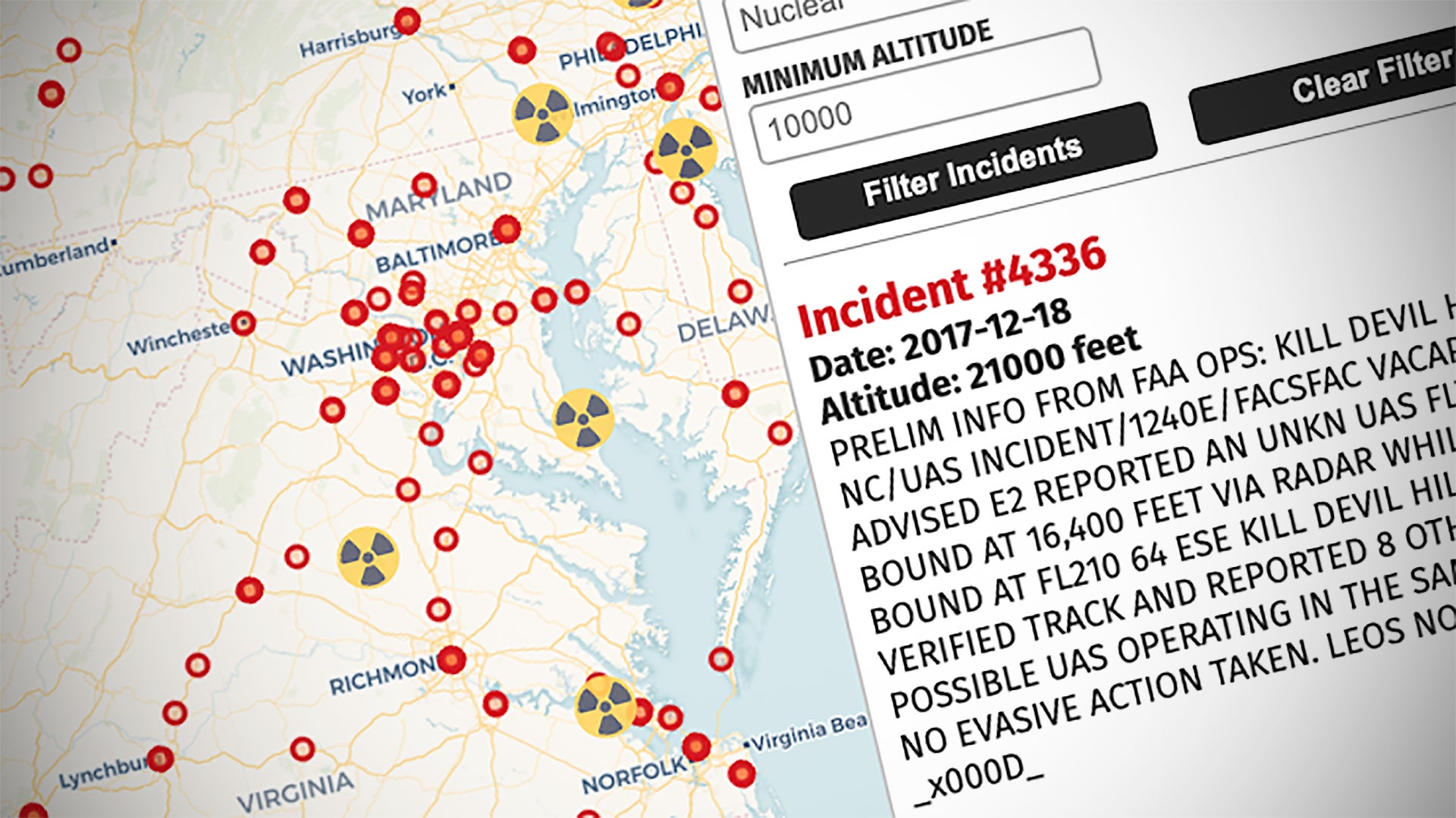
You can also browse the cases in the embedded map below. Due to the prevalence of UAS incidents around strategic infrastructure, we have included the ability to mark key locations on the map to better find incidents. In this initial release, we have incorporated the location of active nuclear reactors in the United States. Those locations are marked with an icon displaying the ionizing radiation hazard symbol.
Please note that due to the number of incidents that the map may take a few moments to load depending on your connection due to the large amount of data:
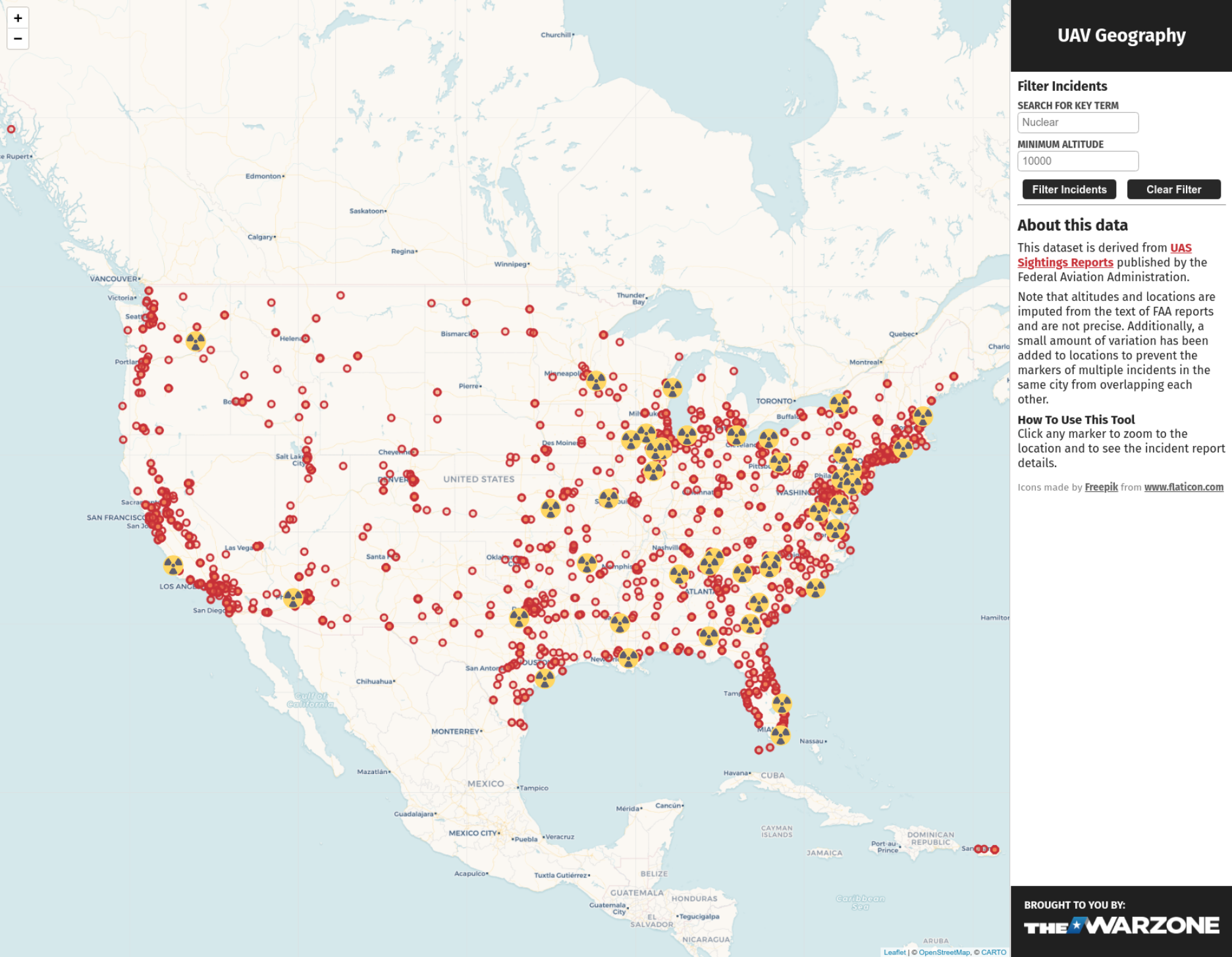
UAVGeography.com
, Screenshot of UAVGeography.com, Adam KehoeThis tool also permits searching the incident reports by keyword. Many of the stories involving UAS described above can be found in the case summaries in this data. In fact, the tool has allowed us to revisit some cases and locations to develop new leads. We invite readers to search and share their own findings with us so we can further investigate ‘unique’ cases. We will be publishing a separate piece shortly detailing a number of new cases that we are investigating and will continue to pursue additional leads.
You can access the tool with its full feature set via this link, as well.
Next Steps
We plan to make updates and improvements to the system over time. This initial release of the tool is designed to quickly give the public access to this data, particularly given the growing concern regarding UAS. As the system grows, we plan to incorporate more search and filtering functionality. We also plan to make further improvements to the location matching system and our ability to extract altitude information. The summary reports also contain a wealth of unstructured information that can be leveraged in the coming weeks, such as references to the color, size and behavior of the UAS.
Our experience navigating and searching the system suggests some possible future directions. For example, we created a separate tool that allows users to visualize incident reports in three dimensions. This capability is particularly useful when viewing urban areas that have a large number of “nuisance” type incidents at lower altitudes. You can see a brief video of the 3d capability below:

We are unable to distribute the 3d version of the application widely without significant costs, but we are offering limited access to analysts interested in trying the tool. Note that this version only includes a different mode of visualizing cases, and otherwise has identical data as the open version.
On the whole, we hope this tool will allow the public to develop a greater appreciation of the scale and seriousness of UAS incidents. The tool may also help provide context for the difficult job of air traffic controllers and pilots to manage an increasingly complex sky. The number and variety of UAS and other craft, like balloons, pose clear challenges for pilots and aircrew to clearly identify what they are seeing, especially given the relatively small size of many of the reported objects. The large community of open-source intelligence professionals and enthusiasts may also play a helpful role in identifying and analyzing significant events. There are some that are very peculiar, involving remarkably high altitudes and multiple craft, among other bizarre factors. As always, The War Zone will continue to update and develop this story as new information and data becomes available.
We will publish an initial analysis of unique cases we have identified using this new tool shortly. We again ask that readers share their tips with us so we can look into other strange incidents that may be buried in the data set.
Contact the author: Adam@thewarzone.com
Loading comments…
Comments couldn’t be loaded. Please refresh the page.